IMAGE OF THE MONTH
courtesy of
MetaVR
An Associate Member of the IMAGE Society
MetaVR develops commercial PC-based software for the military simulation and training markets, featuring high-speed 3D visualization content and rapid creation of networked virtual worlds using real-world data.
Click here to see the full size screenshot.
The full size screenshot from MetaVR Virtual Reality Scene Generator was taken on a 4K monitor at 3840 x 2160 pixel resolution.
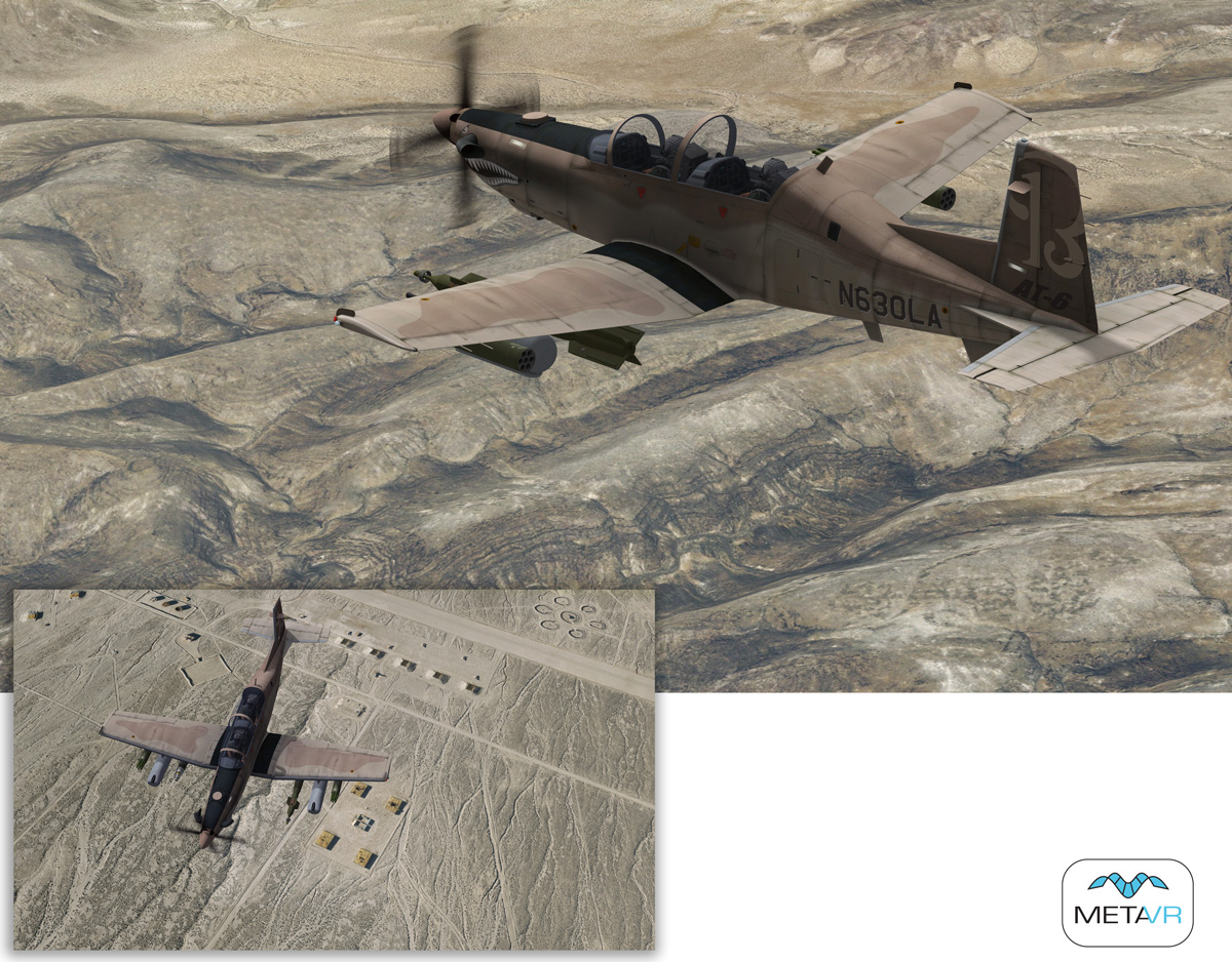
MetaVR's Virtual Fallon Range Training Complex
The two images are real-time scenes from MetaVR's Vitual Reality Scene GeneratorTM (VRSGTM) of a Textron Aviation AT-6B Light Attack Aircraft entity in flight over the high-resolution geospecific 3D terrain of the Naval Air Station (NAS) Fallon Range Training Complex (FRTC). The screen captures were both taken on a 4K monitor at the full-size resolution of 3840 x 2160 pixels. The main image is unaltered; the inset image was resized.
The main image shows the aircraft in flight over a rugged area of terrain. The inset image shows the same aircraft in flight over a detail of a target range at FRTC.
The 65.81 sq km virtual terrain of FRTC was built in our round-earth MetadesicTM terrain format with MetaVR Terrain Tools for EsriArcGIS
The 2 cm per pixel imagery used to build two virtual ranges was captured by MetaVR's small UAV. With the imagery and NED 10 meter elevation data, MetaVR compiled full-resolution (2 cm) terrain tiles of the ranges. (For more information see the following link: www.metavr.com/products/terrain/ranges/fallon.html.)
The 3D terrain is used for training in the Combined Arms Virtual Environment (CAVE) training dome and desktop simulator systems for the NSAWC's Joint Terminal Attack Controller (JTAC) qualification course, for simulation training by students prior to field training on the actual range.
This real-time VRSG scene is running at 60 Hz with a 10-degree field-of-view (full image) and 60 degree field of view (inset image) and a 100 km far horizon. The aircraft entity is from MetaVR's 3D model libraries. In this scene the model shows object-on-object self-shadowing on the aircraft according to the sun orientation, a feature found in VRSG version 6.4.
VRSG is a real-time 3D image generator that provides the fidelity of geospecific simulation with game quality graphics. With real-world data, users can build high-performance virtual worlds with MetaVR's round-earth terrain generation tools and render them at 60Hz frame rates in VRSG.
For more information contact:W. Garth Smith
President and Co-Founder
MetaVR, Inc.
80 Somerset Road
Brookline, MA 02445
Tel: (617) 739-2667
sales@metavr.com
MetaVR and the MetaVR logo are registered trademarks and Virtual Reality Scene Generator, VRSG, and
Metadesic are trademarks of MetaVR, Inc. ArcGIS and Esri are registered trademarks of Esri.
Instructions to Submit your JPEG/GIF file for Image of the Month
